Geolocate

Lucsuhin topographic map

Click on the map to display elevation.

About this map

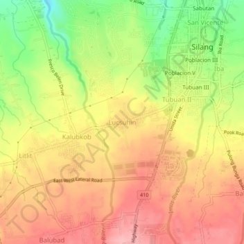
Name: Lucsuhin topographic map, elevation, terrain.

Location: Lucsuhin, Silang, Cavite, Calabarzon, 4118, Philippines (14.19121 120.94058 14.23121 120.98058)

Average elevation: 1,109 ft

Minimum elevation: 863 ft

Maximum elevation: 1,276 ft

Other topographic maps

Click on a map to view its topography, its elevation and its terrain.

Carmen

Philippines > Cavite > Silang

Average elevation: 564 ft

Carmen

Philippines > Cavite > Silang

Average elevation: 564 ft

Gear up for your next adventure:

🔥Fast-Boil Camping Stoves - Efficient cooking systems for quick trail meals
🗺️NatGeo Topo Maps - High-quality waterproof printed topographic maps of US Parks
📻Weather Alert Radios - Stay informed of storm risks while off-the-grid
🧼Biodegradable Camping Soap - Eco‑friendly soap for outdoor hygiene
🎒Gear Packing Cubes - Organize your backpack efficiently

As an Amazon Associate, this site earns from qualifying purchases at no extra cost to you.