
site archéologique carthage dermech topographic map
Interactive map
Click on the map to display elevation.
About this map
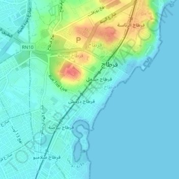
Name: site archéologique carthage dermech topographic map, elevation, terrain.
Average elevation: 39 ft
Minimum elevation: -3 ft
Maximum elevation: 190 ft
Other topographic maps
Click on a map to view its topography, its elevation and its terrain.
Médina de Tunis
Tunisie > Gouvernorat Tunis > Tunis
Médina de Tunis, El Assouak, Délégation Médina, Tunis, Gouvernorat Tunis, Tunisie
Average elevation: 52 ft
Réservoirs d'eau de Burj-Jedid
Tunisie > Gouvernorat Tunis > Tunis
Réservoirs d'eau de Burj-Jedid, Rue de la Liberté, Carthage Plage, Délégation Carthage, Tunis, Gouvernorat Tunis, 2016, Tunisie
Average elevation: 59 ft