Geolocate

Richat Structure topographic map

Click on the map to display elevation.

About this map
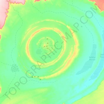
Name: Richat Structure topographic map, elevation, terrain.

Location: Richat Structure, Adrar, Mauritania (20.95626 -11.56260 21.25345 -11.20524)

Average elevation: 1,319 ft

Minimum elevation: 1,145 ft

Maximum elevation: 1,985 ft

Other topographic maps

Click on a map to view its topography, its elevation and its terrain.

Ouadane

Mauritania > Adrar

Average elevation: 1,526 ft

Hofer Tijanna

Mauritania > Adrar

Average elevation: 348 ft

Ouadane

Mauritania > Adrar

Average elevation: 1,526 ft

Ksar el Khâli

Mauritania > Adrar > Ouadane

Average elevation: 1,440 ft

Grâret en Nemra

Mauritania > Adrar

Average elevation: 338 ft

Gear up for your next adventure:

📚Navigation Handbooks - Master the art of reading topographic maps and using a compass
🔌USB Car Charger - Car charger for on‑the‑go power needs
🌎3D Topographic Globes - Raised relief globes for a tactile understanding of geography
🧺Microfiber Travel Towels - Compact and fast-drying towels for trail use
🛡️Insect Repellent - Protection against bugs during outdoor activities

As an Amazon Associate, this site earns from qualifying purchases at no extra cost to you.