
Albenga topographic map
Interactive map
Click on the map to display elevation.
About this map
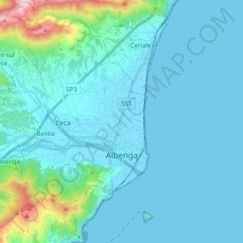
Name: Albenga topographic map, elevation, terrain.
Location: Albenga, Savone, Ligurie, 17031, Italie (44.02287 8.09942 44.10121 8.22985)
Average elevation: 279 ft
Minimum elevation: -3 ft
Maximum elevation: 2,497 ft
Other topographic maps
Click on a map to view its topography, its elevation and its terrain.
Le Ville
Italie > Ligurie > Savone > Cairo Montenotte
Le Ville, Cairo Montenotte, Savone, Ligurie, 17014, Italie
Average elevation: 1,339 ft
Cairo Montenotte
Cairo Montenotte, Savone, Ligurie, Italie
Average elevation: 1,608 ft
Celle Ligure
Celle Ligure, Savone, Ligurie, 17015, Italie
Average elevation: 394 ft
Calice Ligure
Calice Ligure, Savone, Ligurie, Italie
Average elevation: 1,617 ft
Finale Ligure
Finale Ligure, Savone, Ligurie, 17024, Italie
Average elevation: 535 ft
Pietra Ligure
Pietra Ligure, Savone, Ligurie, 17027, Italie
Average elevation: 358 ft