
San Francisco topographic map
Interactive map
Click on the map to display elevation.
About this map
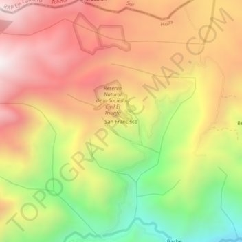
Name: San Francisco topographic map, elevation, terrain.
Location: San Francisco, Santa María, Norte, Huila, Colombia (2.94960 -75.68820 2.98960 -75.64820)
Average elevation: 7,943 ft
Minimum elevation: 5,679 ft
Maximum elevation: 9,797 ft
Other topographic maps
Click on a map to view its topography, its elevation and its terrain.
Carmen De Bolívar
Colombia > Huila > Santa María
Carmen De Bolívar, Santa María, Norte, Huila, RAP (Especial) Central, Colombia
Average elevation: 8,517 ft
Río Bache
Colombia > Huila > Santa María
Río Bache, Santa María, Norte, Huila, RAP (Especial) Central, Colombia
Average elevation: 4,144 ft