
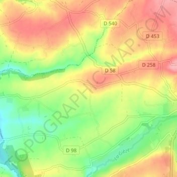
La Croix des Tondieres topographic map
Interactive map
Click on the map to display elevation.
About this map
Name: La Croix des Tondieres topographic map, elevation, terrain.
Average elevation: 397 ft
Minimum elevation: 217 ft
Maximum elevation: 568 ft
Other topographic maps
Click on a map to view its topography, its elevation and its terrain.
La Goupillière
France > Normandie > Manche > Percy-en-Normandie > Percy
La Goupillière, Percy, Percy-en-Normandie, Saint-Lô, Manche, Normandie, France métropolitaine, 50410, France
Average elevation: 348 ft
Le Moulin de Haut
France > Normandie > Manche > Percy-en-Normandie > Percy
Le Moulin de Haut, Percy, Percy-en-Normandie, Saint-Lô, Manche, Normandie, France métropolitaine, 50410, France
Average elevation: 456 ft