
South Greeley topographic map
Interactive map
Click on the map to display elevation.
About this map
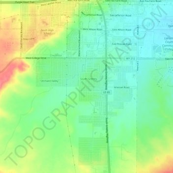
Name: South Greeley topographic map, elevation, terrain.
Average elevation: 6,060 ft
Minimum elevation: 5,974 ft
Maximum elevation: 6,204 ft
Other topographic maps
Click on a map to view its topography, its elevation and its terrain.
Ranchettes
United States > Wyoming > Laramie County > Cheyenne
Ranchettes, Cheyenne, Laramie County, Wyoming, 82009, United States
Average elevation: 6,132 ft
Cheyenne
United States > Wyoming > Laramie County > Cheyenne
Cheyenne, Laramie County, Wyoming, 82002, United States
Average elevation: 6,204 ft
Sloans Lake
United States > Wyoming > Laramie County > Cheyenne
Sloans Lake, Cheyenne, Laramie County, Wyoming, United States
Average elevation: 6,138 ft