Geolocate

Guiuan topographic map

Click on the map to display elevation.

About this map

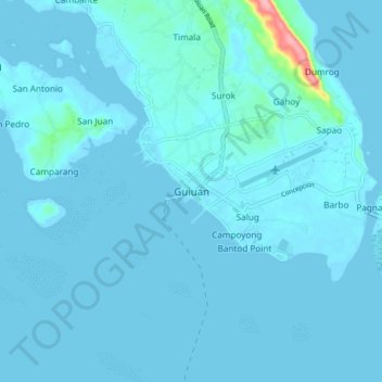
Name: Guiuan topographic map, elevation, terrain.

Location: Guiuan, Eastern Samar, Eastern Visayas, 6808, Philippines (10.99051 125.68381 11.07051 125.76381)

Average elevation: 20 ft

Minimum elevation: -13 ft

Maximum elevation: 387 ft

Other topographic maps

Click on a map to view its topography, its elevation and its terrain.

Homonhon Island

Philippines > Eastern Samar > Cagusu-an

Average elevation: 89 ft

Llorente River

Philippines > Eastern Samar > Can-ato

Average elevation: 243 ft

Suribao River

Philippines > Eastern Samar > Banuyo

Average elevation: 344 ft

Dolores River

Philippines > Eastern Samar

Average elevation: 341 ft

Oras

Philippines > Eastern Samar > Jipapad

Average elevation: 121 ft

Gear up for your next adventure:

🛌Ultralight Sleeping Bags - Compact down bags for cold nights in the wilderness
🧢Outdoor Hiking Hat - Sun protection hat for outdoor explorers
Backpacking Tent - Lightweight and durable tent for multi‑day hikes
🧦Hiking Socks - Comfortable socks to prevent blisters on long hikes
🎒Gear Packing Cubes - Organize your backpack efficiently

As an Amazon Associate, this site earns from qualifying purchases at no extra cost to you.