
2nd Community of Heraklion - Eastern topographic map
Interactive map
Click on the map to display elevation.
About this map
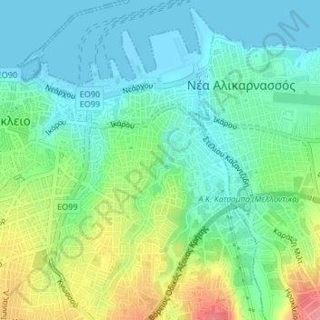
Name: 2nd Community of Heraklion - Eastern topographic map, elevation, terrain.
Average elevation: 95 ft
Minimum elevation: -10 ft
Maximum elevation: 315 ft
Other topographic maps
Click on a map to view its topography, its elevation and its terrain.
Bethlehem Gate
Greece > Region of Crete > Heraklion Regional Unit > Heraklion Municipal Unit
Bethlehem Gate, Νικολάου Πλαστήρα, Καμίνια, 3rd Community of Heraklion - Western, Heraklion Municipal Unit, Municipality of Heraklion, Heraklion Regional Unit, Region of Crete, 713 05, Greece
Average elevation: 105 ft
Heraklion Municipal Unit
Greece > Region of Crete > Heraklion Regional Unit > Heraklion Municipal Unit
Heraklion Municipal Unit, Municipality of Heraklion, Heraklion Regional Unit, Region of Crete, Greece
Average elevation: 768 ft