
Tubo-tubo topographic map
Interactive map
Click on the map to display elevation.
About this map
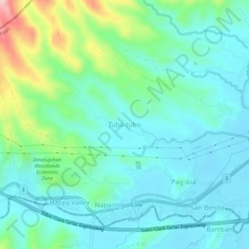
Name: Tubo-tubo topographic map, elevation, terrain.
Average elevation: 203 ft
Minimum elevation: 36 ft
Maximum elevation: 784 ft
Other topographic maps
Click on a map to view its topography, its elevation and its terrain.
Sapang Balas
Philippines > Bataan > Dinalupihan
Sapang Balas, Dinalupihan, Bataan, Central Luzon, 2110, Philippines
Average elevation: 79 ft
Pentor
Philippines > Bataan > Dinalupihan
Pentor, Dinalupihan, Bataan, Central Luzon, 2110, Philippines
Average elevation: 36 ft
Saguing
Philippines > Bataan > Dinalupihan
Saguing, Dinalupihan, Bataan, Central Luzon, 2110, Philippines
Average elevation: 62 ft