
Jasmine Glen Estates topographic map
Interactive map
Click on the map to display elevation.
About this map
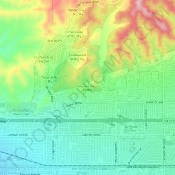
Name: Jasmine Glen Estates topographic map, elevation, terrain.
Average elevation: 1,086 ft
Minimum elevation: 794 ft
Maximum elevation: 1,634 ft
Other topographic maps
Click on a map to view its topography, its elevation and its terrain.
Simi Valley
United States > California > Ventura County > Simi Valley
Simi Valley, Ventura County, California, 93063-2364, United States
Average elevation: 1,243 ft
Strathearn
United States > California > Ventura County > Simi Valley
Strathearn, Simi Valley, Ventura County, CAL Fire Southern Region, California, 93065, United States
Average elevation: 856 ft