Geolocate

Highland topographic map

Click on the map to display elevation.

About this map

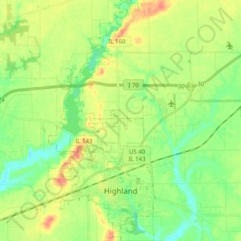
Name: Highland topographic map, elevation, terrain.

Location: Highland, Madison County, Illinois, United States (38.71719 -89.71242 38.82435 -89.65131)

Average elevation: 535 ft

Minimum elevation: 466 ft

Maximum elevation: 630 ft

Madison County trails, hiking, mountain biking, running and outdoor activities

Other topographic maps

Click on a map to view its topography, its elevation and its terrain.

North Venice

United States > Illinois > Madison County > Venice

Average elevation: 413 ft

North Alton

United States > Illinois > Madison County > Godfrey

Average elevation: 587 ft

Bethalto

United States > Illinois > Madison County > Bethalto > Bethalto

Average elevation: 512 ft

Alton

United States > Illinois > Madison County > Alton

Average elevation: 482 ft

Gear up for your next adventure:

🔭Telescopic Hiking Pole - Adjustable pole for hiking stability
⛑️Personal Locator Beacon - Safety beacon for emergencies
🧣Merino Neck Gaiters - Multi-functional headwear for wind and sun protection
🗺️Topographic Maps - Detailed topo maps for hiking, exploring and outdoor navigation
🪶Camping Sleeping Pad - Comfortable sleeping pad for backpacking

As an Amazon Associate, this site earns from qualifying purchases at no extra cost to you.