
Zanskar topographic map
Interactive map
Click on the map to display elevation.
About this map
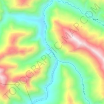
Name: Zanskar topographic map, elevation, terrain.
Location: Zanskar, Leh Tehsil, Leh district, Ladakh, India (33.93332 77.19482 34.00233 77.21423)
Average elevation: 12,175 ft
Minimum elevation: 10,220 ft
Maximum elevation: 15,387 ft
Other topographic maps
Click on a map to view its topography, its elevation and its terrain.
Sumdo
India > Ladakh > Leh Tehsil
Sumdo, Leh Tehsil, Leh District, Ladakh, India
Average elevation: 15,299 ft
Indus
India > Ladakh > Leh Tehsil
Indus, Leh Tehsil, Leh District, Ladakh, India
Average elevation: 13,753 ft
Leh
India > Ladakh > Leh Tehsil
Leh, Leh Tehsil, Leh district, Ladakh, India
Average elevation: 11,985 ft