
Howell topographic map
Click on the map to display elevation.
About this map
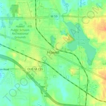
Name: Howell topographic map, elevation, terrain.
Location: Howell, Livingston County, Michigan, 48844, United States (42.58461 -83.96553 42.62936 -83.91242)
Average elevation: 925 ft
Minimum elevation: 876 ft
Maximum elevation: 997 ft
Livingston County trails, hiking, mountain biking, running and outdoor activities
Other topographic maps
Click on a map to view its topography, its elevation and its terrain.
Green Oak
United States > Michigan > Livingston County > Green Oak Charter Township
Average elevation: 902 ft
Rushton
United States > Michigan > Livingston County > Green Oak Charter Township
Average elevation: 902 ft
Whitmore Lake
United States > Michigan > Livingston County > Green Oak Township > Whitmore Lake
Average elevation: 906 ft