Geolocate

French Lick topographic map

Click on the map to display elevation.

About this map

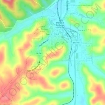
Name: French Lick topographic map, elevation, terrain.

Location: French Lick, Orange County, Indiana, United States (38.52687 -86.64297 38.56156 -86.60336)

Average elevation: 610 ft

Minimum elevation: 466 ft

Maximum elevation: 814 ft

Orange County trails, hiking, mountain biking, running and outdoor activities

Other topographic maps

Click on a map to view its topography, its elevation and its terrain.

Youngs Creek

United States > Indiana > Orange County

Average elevation: 728 ft

Bacon

United States > Indiana > Orange County

Average elevation: 715 ft

Gear up for your next adventure:

🥾Men's Hiking Boots - Durable, waterproof footwear for rugged terrain and steep inclines
🧭Hiking Compass - Precision compass for reliable navigation in the wilderness
🪶Thermal Camp Blanket - Extra warmth for cold nights
📱Solar Portable Charger - Solar power bank for charging devices off‑grid
🔌USB Car Charger - Car charger for on‑the‑go power needs

As an Amazon Associate, this site earns from qualifying purchases at no extra cost to you.