
Make a donation
Gear up for your next adventure:
As an Amazon Associate, this site earns from qualifying purchases at no extra cost to you.
Calvinia topographic map
Click on the map to display elevation.
Make a donation
Gear up for your next adventure:
As an Amazon Associate, this site earns from qualifying purchases at no extra cost to you.
Calvinia
The town is 301 kilometers (470 kilometers by tar road) north of Cape Town and lies at an altitude of 970 meters.
Make a donation
Gear up for your next adventure:
As an Amazon Associate, this site earns from qualifying purchases at no extra cost to you.
About this map
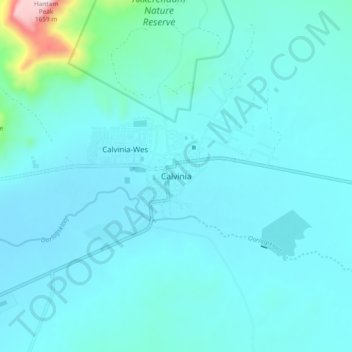
Name: Calvinia topographic map, elevation, terrain.
Average elevation: 3,356 ft
Minimum elevation: 3,150 ft
Maximum elevation: 5,276 ft
Make a donation
Gear up for your next adventure:
As an Amazon Associate, this site earns from qualifying purchases at no extra cost to you.
Other topographic maps
Click on a map to view its topography, its elevation and its terrain.
Hantam National Botanical Garden
South Africa > Northern Cape > Namakwa District Municipality > Hantam Local Municipality
Average elevation: 2,290 ft