
Gemeinde Silz topographic map
Interactive map
Click on the map to display elevation.
About this map
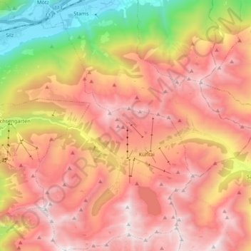
Name: Gemeinde Silz topographic map, elevation, terrain.
Location: Gemeinde Silz, Bezirk Imst, Tyrol, Austria (47.17042 10.89743 47.28239 11.05366)
Average elevation: 6,542 ft
Minimum elevation: 2,077 ft
Maximum elevation: 9,770 ft
Other topographic maps
Click on a map to view its topography, its elevation and its terrain.
Martin-Busch-Hütte
Austria > Tyrol > Bezirk Imst > Gemeinde Sölden
Martin-Busch-Hütte, 403, Hütten Vent, Gemeinde Sölden, Bezirk Imst, Tyrol, 6458, Austria
Average elevation: 8,796 ft