Geolocate

Mincy topographic map

Click on the map to display elevation.

About this map

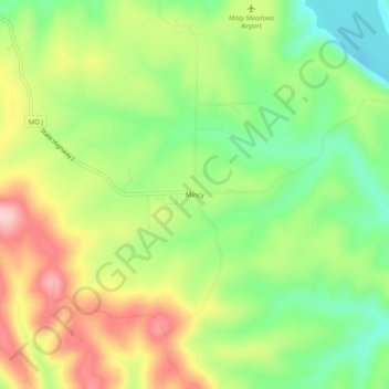
Name: Mincy topographic map, elevation, terrain.

Location: Mincy, Taney County, Missouri, 67679, United States (36.54423 -93.13018 36.58423 -93.09018)

Average elevation: 912 ft

Minimum elevation: 610 ft

Maximum elevation: 1,293 ft

Taney County trails, hiking, mountain biking, running and outdoor activities

Other topographic maps

Click on a map to view its topography, its elevation and its terrain.

Kirbyville

United States > Missouri > Taney County

Average elevation: 988 ft

Bradleyville

United States > Missouri > Taney County

Average elevation: 925 ft

Rockaway Beach

United States > Missouri > Taney County

Average elevation: 827 ft

Bull Creek

United States > Missouri > Taney County

Average elevation: 840 ft

Kirbyville

United States > Missouri > Taney County

Average elevation: 981 ft

Gear up for your next adventure:

🕶️GPS Smartphone Mount - Secure mount for phone navigation
🔌USB Car Charger - Car charger for on‑the‑go power needs
🚗GPS Dash Cams - Record your scenic drives through mountain passes and canyons
🪶Fire Starter Kit - Reliable fire starter for survival and camping
🧭Outdoor Navigation Book - Learn advanced navigation skills

As an Amazon Associate, this site earns from qualifying purchases at no extra cost to you.