Geolocate

Mosheim topographic map

Click on the map to display elevation.

About this map

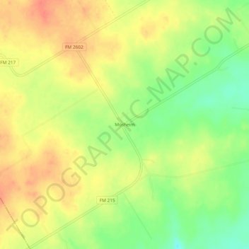
Name: Mosheim topographic map, elevation, terrain.

Location: Mosheim, Bosque County, Texas, United States (31.60627 -97.62002 31.64627 -97.58002)

Average elevation: 938 ft

Minimum elevation: 843 ft

Maximum elevation: 1,010 ft

Bosque County trails, hiking, mountain biking, running and outdoor activities

Other topographic maps

Click on a map to view its topography, its elevation and its terrain.

Walnut Springs

United States > Texas > Bosque County

Average elevation: 942 ft

Cranfills Gap

United States > Texas > Bosque County

Average elevation: 997 ft

Iredell

United States > Texas > Bosque County

Average elevation: 912 ft

Morgan

United States > Texas > Bosque County

Average elevation: 745 ft

Clifton

United States > Texas > Bosque County

Average elevation: 715 ft

Gear up for your next adventure:

🧭Map Reading Tools - Tools and kits for map navigation
🗃️Trail First Aid Kit - Essential kit for outdoor injuries and emergencies
🧭GPS Watch Accessories - Bands and chargers for GPS watches
🌡️Handheld Weather Meters - Measure wind, temp, and pressure for safe mountain travel
Backpacking Tents - Weight-optimized shelters for multi-day topographic surveys

As an Amazon Associate, this site earns from qualifying purchases at no extra cost to you.