
Weißenburg i. Bay. topographic map
Interactive map
Click on the map to display elevation.
About this map
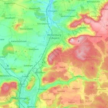
Name: Weißenburg i. Bay. topographic map, elevation, terrain.
Average elevation: 1,608 ft
Minimum elevation: 1,266 ft
Maximum elevation: 2,090 ft
Other topographic maps
Click on a map to view its topography, its elevation and its terrain.
Absberg
Allemagne > Bavière > Weissenburg-Gunzenhausen
Absberg, Gunzenhausen (VGem), Weissenburg-Gunzenhausen, Bavière, 91720, Allemagne
Average elevation: 1,453 ft
Weißenburg in Bayern
Allemagne > Bavière > Weissenburg-Gunzenhausen > Weißenburg i. Bay. > Weißenburg in Bayern
Weißenburg in Bayern, Weißenburg i. Bay., Weissenburg-Gunzenhausen, Bavière, 91781, Allemagne
Average elevation: 1,555 ft
Treuchtlingen
Allemagne > Bavière > Weissenburg-Gunzenhausen
Treuchtlingen, Weissenburg-Gunzenhausen, Bavière, 91757, Allemagne
Average elevation: 1,654 ft