
Cheniguel topographic map
Interactive map
Click on the map to display elevation.
About this map
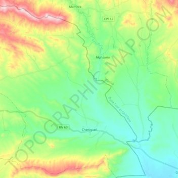
Name: Cheniguel topographic map, elevation, terrain.
Location: Cheniguel, Daïra Chellalet El Adhaoura, Médéa, Algérie (35.88034 3.44287 36.03904 3.62907)
Average elevation: 2,766 ft
Minimum elevation: 2,165 ft
Maximum elevation: 4,114 ft
Other topographic maps
Click on a map to view its topography, its elevation and its terrain.
Zaatria
Algérie > Médéa > Daïra Chellalet El Adhaoura
Zaatria, Tafraout, Daïra Chellalet El Adhaoura, Médéa, Algérie
Average elevation: 3,583 ft
Aïn Ouksir
Algérie > Médéa > Daïra Chellalet El Adhaoura
Aïn Ouksir, Daïra Chellalet El Adhaoura, Médéa, Algérie
Average elevation: 2,369 ft