
Ruiter topographic map
Interactive map
Click on the map to display elevation.
About this map
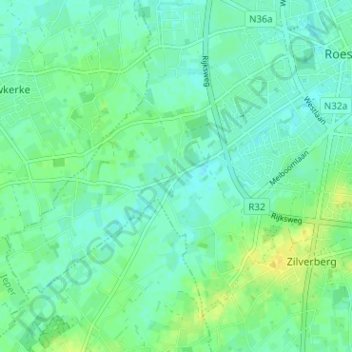
Name: Ruiter topographic map, elevation, terrain.
Location: Ruiter, Roeselare, West-Vlaanderen, 8800, België (50.91054 3.07286 50.95054 3.11286)
Average elevation: 82 ft
Minimum elevation: 59 ft
Maximum elevation: 125 ft
Other topographic maps
Click on a map to view its topography, its elevation and its terrain.
Rumbeke
België > West-Vlaanderen > Roeselare > Roeselare
Rumbeke, Roeselare, West-Vlaanderen, België
Average elevation: 75 ft
Oekene
België > West-Vlaanderen > Roeselare > Roeselare
Oekene, Roeselare, West-Vlaanderen, België
Average elevation: 79 ft
Beveren
België > West-Vlaanderen > Roeselare > Roeselare
Beveren, Roeselare, West-Vlaanderen, België
Average elevation: 79 ft
Beitem
België > West-Vlaanderen > Roeselare > Roeselare
Beitem, Roeselare, West-Vlaanderen, 8890, België
Average elevation: 85 ft