
Thank you for supporting this site ❤️
Make a donation
Make a donation
Gear up for your next adventure:
As an Amazon Associate, this site earns from qualifying purchases at no extra cost to you.
Hilden topographic map
Click on the map to display elevation.
Thank you for supporting this site ❤️
Make a donation
Make a donation
Gear up for your next adventure:
As an Amazon Associate, this site earns from qualifying purchases at no extra cost to you.
About this map
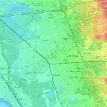
Name: Hilden topographic map, elevation, terrain.
Location: Hilden, Kreis Mettmann, North Rhine-Westphalia, Germany (51.14050 6.89076 51.19806 6.98660)
Average elevation: 180 ft
Minimum elevation: 112 ft
Maximum elevation: 364 ft
Thank you for supporting this site ❤️
Make a donation
Make a donation
Gear up for your next adventure:
As an Amazon Associate, this site earns from qualifying purchases at no extra cost to you.
Other topographic maps
Click on a map to view its topography, its elevation and its terrain.
Abtsküche / Haus Hetterscheidt
Germany > North Rhine-Westphalia > Kreis Mettmann > Heiligenhaus > Tüschen
Average elevation: 551 ft