
West Sulawesi topographic map
Interactive map
Click on the map to display elevation.
About this map
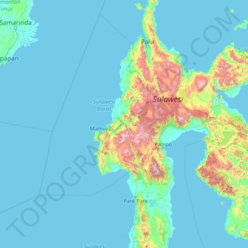
Name: West Sulawesi topographic map, elevation, terrain.
Location: West Sulawesi, Indonesia (-5.05745 116.83190 0.06255 121.95190)
Average elevation: 719 ft
Minimum elevation: -10 ft
Maximum elevation: 10,436 ft
Other topographic maps
Click on a map to view its topography, its elevation and its terrain.
Tanete Gandangdewata
Indonesia > West Sulawesi > Mamuju
Tanete Gandangdewata, Mamuju, West Sulawesi, Indonesia
Average elevation: 9,075 ft