
Make a donation
Gear up for your next adventure:
As an Amazon Associate, this site earns from qualifying purchases at no extra cost to you.
Sanok topographic map
Click on the map to display elevation.
Make a donation
Gear up for your next adventure:
As an Amazon Associate, this site earns from qualifying purchases at no extra cost to you.
Sanok
This historic city is situated on the San River at the foot of Castle Hill in the Lesser Poland (Małopolska) region. It lies in a wooded, hilly area near the national road number 28, which runs along southern Poland, from Ustrzyki Dolne to Wadowice (340 km or 211 mi away). It is located in the heartland of the Pogórze Bukowskie part of Doły (Pits), and its average elevation is 300 m (984 ft) above sea level, although there are some hills located within the confines of the city.
Make a donation
Gear up for your next adventure:
As an Amazon Associate, this site earns from qualifying purchases at no extra cost to you.
About this map
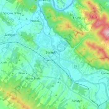
Name: Sanok topographic map, elevation, terrain.
Location: Sanok, Sanok County, Subcarpathian Voivodeship, 38-500, Poland (49.52281 22.14730 49.59510 22.28378)
Average elevation: 1,161 ft
Minimum elevation: 889 ft
Maximum elevation: 2,185 ft
Make a donation
Gear up for your next adventure:
As an Amazon Associate, this site earns from qualifying purchases at no extra cost to you.