
Nong Khai Province topographic map
Interactive map
Click on the map to display elevation.
About this map
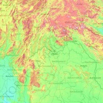
Name: Nong Khai Province topographic map, elevation, terrain.
Location: Nong Khai Province, Thailand (15.37014 99.90498 20.49014 105.02498)
Average elevation: 1,486 ft
Minimum elevation: 62 ft
Maximum elevation: 8,625 ft
Other topographic maps
Click on a map to view its topography, its elevation and its terrain.
Nong Khai
Nong Khai, Pho Chai, Nong Khai Province, 43000, Thailand
Average elevation: 551 ft