
Ua Huka topographic map
Interactive map
Click on the map to display elevation.
About this map
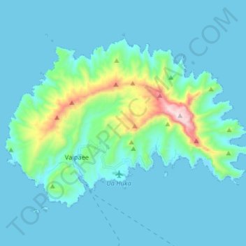
Name: Ua Huka topographic map, elevation, terrain.
Average elevation: 331 ft
Minimum elevation: -3 ft
Maximum elevation: 2,838 ft
Other topographic maps
Click on a map to view its topography, its elevation and its terrain.
Hoa
France > French Polynesia > Ua Huka
Hoa, Ua Huka, Marquesas Islands, French Polynesia, France
Average elevation: 240 ft