
Make a donation
Gear up for your next adventure:
As an Amazon Associate, this site earns from qualifying purchases at no extra cost to you.
Saint-Just topographic map
Click on the map to display elevation.
Make a donation
Gear up for your next adventure:
As an Amazon Associate, this site earns from qualifying purchases at no extra cost to you.
About this map
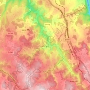
Name: Saint-Just topographic map, elevation, terrain.
Average elevation: 3,235 ft
Minimum elevation: 2,510 ft
Maximum elevation: 3,619 ft
Make a donation
Gear up for your next adventure:
As an Amazon Associate, this site earns from qualifying purchases at no extra cost to you.
Other topographic maps
Click on a map to view its topography, its elevation and its terrain.
Le Chassan
France > Auvergne-Rhône-Alpes > Cantal > Val d'Arcomie > Faverolles
Average elevation: 2,894 ft
La Brugère
France > Auvergne-Rhône-Alpes > Cantal > Val d'Arcomie > Faverolles > La Brugère
Average elevation: 2,726 ft
Make a donation
Gear up for your next adventure:
As an Amazon Associate, this site earns from qualifying purchases at no extra cost to you.
Lascoux
France > Auvergne-Rhône-Alpes > Cantal > Val d'Arcomie > Saint-Just > Lascoux
Average elevation: 3,140 ft
La Roche
France > Auvergne-Rhône-Alpes > Cantal > Val d'Arcomie > Saint-Marc
Average elevation: 3,130 ft
Montchanson
France > Auvergne-Rhône-Alpes > Cantal > Val d'Arcomie > Faverolles
Average elevation: 3,094 ft
Make a donation
Gear up for your next adventure:
As an Amazon Associate, this site earns from qualifying purchases at no extra cost to you.
Estrémiac
France > Auvergne-Rhône-Alpes > Cantal > Val d'Arcomie > Saint-Just > Estrémiac
Average elevation: 3,205 ft
Le Moulin des Mazes
France > Auvergne-Rhône-Alpes > Cantal > Val d'Arcomie > Saint-Marc > Le Moulin des Mazes
Average elevation: 3,114 ft