
Make a donation
Gear up for your next adventure:
As an Amazon Associate, this site earns from qualifying purchases at no extra cost to you.
Nîmes topographic map
Click on the map to display elevation.
Make a donation
Gear up for your next adventure:
As an Amazon Associate, this site earns from qualifying purchases at no extra cost to you.
About this map
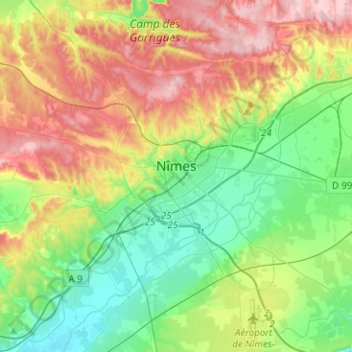
Name: Nîmes topographic map, elevation, terrain.
Location: Nîmes, Gard, Occitania, Metropolitan France, France (43.74127 4.23567 43.92302 4.44966)
Average elevation: 295 ft
Minimum elevation: 46 ft
Maximum elevation: 702 ft
Make a donation
Gear up for your next adventure:
As an Amazon Associate, this site earns from qualifying purchases at no extra cost to you.
Other topographic maps
Click on a map to view its topography, its elevation and its terrain.
Make a donation
Gear up for your next adventure:
As an Amazon Associate, this site earns from qualifying purchases at no extra cost to you.
Make a donation
Gear up for your next adventure:
As an Amazon Associate, this site earns from qualifying purchases at no extra cost to you.
La Bégude de Vers-Pont-du-Gard
France > Occitania > Gard > Vers-Pont-du-Gard
Average elevation: 187 ft