
Hammam Boughrara topographic map
Interactive map
Click on the map to display elevation.
About this map
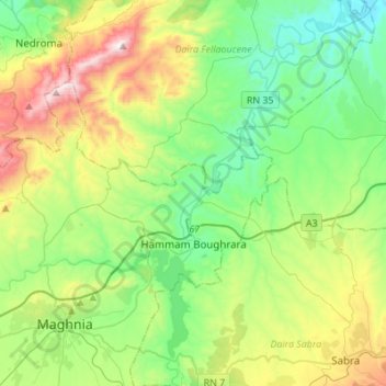
Name: Hammam Boughrara topographic map, elevation, terrain.
Location: Hammam Boughrara, Daïra Maghnia, Tlemcen, 13036, Algérie (34.85786 -1.85523 34.98798 -1.58148)
Average elevation: 1,375 ft
Minimum elevation: 367 ft
Maximum elevation: 3,678 ft
Other topographic maps
Click on a map to view its topography, its elevation and its terrain.
Almaâziz
Algérie > Tlemcen > Daïra Maghnia > Hammam Boughrara
Almaâziz, Hammam Boughrara, Daïra Maghnia, Tlemcen, Algérie
Average elevation: 1,906 ft