
Cantón Puntarenas topographic map
Interactive map
Click on the map to display elevation.
About this map
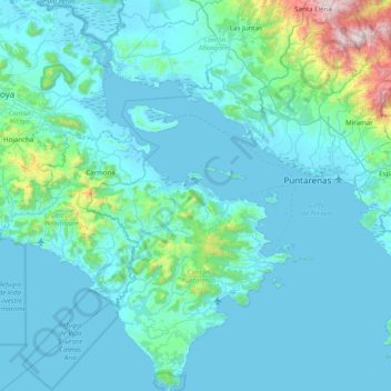
Name: Cantón Puntarenas topographic map, elevation, terrain.
Location: Cantón Puntarenas, Provincia Puntarenas, Costa Rica (9.55900 -85.27974 10.33511 -84.66163)
Average elevation: 489 ft
Minimum elevation: -3 ft
Maximum elevation: 6,001 ft
Other topographic maps
Click on a map to view its topography, its elevation and its terrain.
Pascua
Costa Rica > Provincia Puntarenas > Pascua
Pascua, Cantón Quepos, Provincia Puntarenas, 60601, Costa Rica
Average elevation: 102 ft