
Make a donation
Gear up for your next adventure:
As an Amazon Associate, this site earns from qualifying purchases at no extra cost to you.
Albinen topographic map
Click on the map to display elevation.
Make a donation
Gear up for your next adventure:
As an Amazon Associate, this site earns from qualifying purchases at no extra cost to you.
Albinen
The flora changes with the different altitudes of the territory. The lower areas are dominated by woods and meadows. The countryside changes to mountain meadows, rocks and cliffs at the higher altitudes. A large variety of wild flowers can be found, especially during spring and in the early summer when most of them flourish. In autumn the larch trees turn yellow and bushes appear at all kinds of red, orange and yellow colouring.
Make a donation
Gear up for your next adventure:
As an Amazon Associate, this site earns from qualifying purchases at no extra cost to you.
About this map
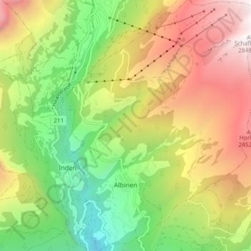
Name: Albinen topographic map, elevation, terrain.
Location: Albinen, Leuk, Wallis, 3955, Switzerland (46.32745 7.61533 46.37732 7.67087)
Average elevation: 5,571 ft
Minimum elevation: 2,513 ft
Maximum elevation: 9,308 ft
Make a donation
Gear up for your next adventure:
As an Amazon Associate, this site earns from qualifying purchases at no extra cost to you.
Other topographic maps
Click on a map to view its topography, its elevation and its terrain.