Geolocate

Mahe topographic map

Click on the map to display elevation.

About this map

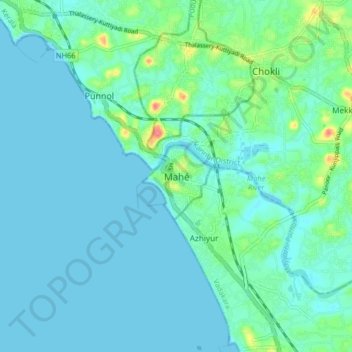
Name: Mahe topographic map, elevation, terrain.

Location: Mahe, Mahe Taluk, Mahé, Puducherry, 673310, India (11.66220 75.49647 11.74220 75.57647)

Average elevation: 33 ft

Minimum elevation: -3 ft

Maximum elevation: 203 ft

Gear up for your next adventure:

🔋Rechargeable Batteries - Power up your outdoor devices
🌲Outdoor Survival Books - Best books on survival skills
🛠️Outdoor Gear Repair Kit - Essential tools to fix gear on the trail
🧣Merino Neck Gaiters - Multi-functional headwear for wind and sun protection
📦Gear Storage Bags - Organize and protect outdoor equipment

As an Amazon Associate, this site earns from qualifying purchases at no extra cost to you.