
Râmnicu Sărat topographic map
Interactive map
Click on the map to display elevation.
About this map
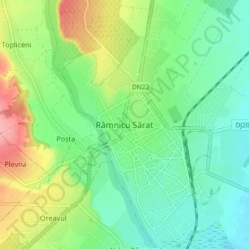
Name: Râmnicu Sărat topographic map, elevation, terrain.
Location: Râmnicu Sărat, Buzău, 125300, Romania (45.36255 27.02837 45.40844 27.07034)
Average elevation: 420 ft
Minimum elevation: 318 ft
Maximum elevation: 633 ft
Other topographic maps
Click on a map to view its topography, its elevation and its terrain.
Bâsca Chiojdului
Bâsca Chiojdului, Chiojdu, Buzău, 127171, Romania
Average elevation: 2,402 ft