
Make a donation
Gear up for your next adventure:
As an Amazon Associate, this site earns from qualifying purchases at no extra cost to you.
Bâsca Chiojdului topographic map
Click on the map to display elevation.
Make a donation
Gear up for your next adventure:
As an Amazon Associate, this site earns from qualifying purchases at no extra cost to you.
About this map
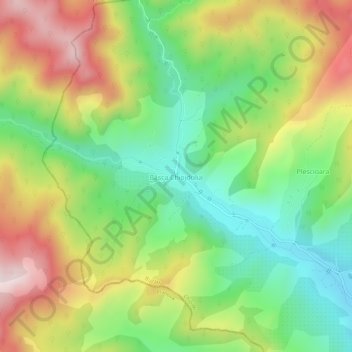
Name: Bâsca Chiojdului topographic map, elevation, terrain.
Location: Bâsca Chiojdului, Chiojdu, Buzău, 127171, Romania (45.35520 26.15509 45.39520 26.19509)
Average elevation: 2,402 ft
Minimum elevation: 1,604 ft
Maximum elevation: 3,481 ft
Make a donation
Gear up for your next adventure:
As an Amazon Associate, this site earns from qualifying purchases at no extra cost to you.
Other topographic maps
Click on a map to view its topography, its elevation and its terrain.
Buzău
The city is located in the center of the county, 100 km north-east of Bucharest, in the South-East of Romania, taking up a total area of 81,3 km2, at the outermost curvature of the Subcarpathian foothills, at the crossroads of the three main Romanian historical provinces: Wallachia, Transylvania and Moldavia.…
Average elevation: 315 ft