Geolocate

Carballo topographic map

Click on the map to display elevation.

About this map
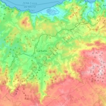
Name: Carballo topographic map, elevation, terrain.

Location: Carballo, Bergantiños, A Coruña, Galicia, Spain (43.10174 -8.77499 43.31530 -8.58257)

Average elevation: 738 ft

Minimum elevation: -7 ft

Maximum elevation: 1,936 ft

Other topographic maps

Click on a map to view its topography, its elevation and its terrain.
Cercido

Spain > Galicia > Bergantiños

Average elevation: 984 ft

Moucos

Spain > Galicia > Bergantiños

Average elevation: 1,184 ft

A Laracha

Spain > Galicia > Bergantiños

Average elevation: 610 ft

Nebrexe

Spain > Galicia > Bergantiños

Average elevation: 1,138 ft

As Brañas

Spain > Galicia > Bergantiños > A Laracha

Average elevation: 577 ft

Gear up for your next adventure:

🪄Magnetic Compass - Accurate compass for navigation
🦟Ultrasonic Repellers - Create a bug-free zone at your camp or rest stop
🎒Day Hiking Backpack - Lightweight backpack perfect for day trips and outdoor adventures
☕Camping Coffee Makers - Enjoy premium coffee at the summit or campsite
🗺️NatGeo Topo Maps - High-quality waterproof printed topographic maps of US Parks

As an Amazon Associate, this site earns from qualifying purchases at no extra cost to you.