
Make a donation
Gear up for your next adventure:
As an Amazon Associate, this site earns from qualifying purchases at no extra cost to you.
Makhanda topographic map
Click on the map to display elevation.
Make a donation
Gear up for your next adventure:
As an Amazon Associate, this site earns from qualifying purchases at no extra cost to you.
About this map
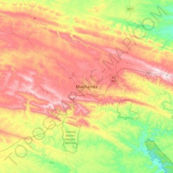
Name: Makhanda topographic map, elevation, terrain.
Average elevation: 1,503 ft
Minimum elevation: 331 ft
Maximum elevation: 2,782 ft
Make a donation
Gear up for your next adventure:
As an Amazon Associate, this site earns from qualifying purchases at no extra cost to you.
Other topographic maps
Click on a map to view its topography, its elevation and its terrain.
Thyspunt
South Africa > Eastern Cape > Sarah Baartman District Municipality > Kouga Local Municipality
Average elevation: 269 ft
Gamtoos River
South Africa > Eastern Cape > Sarah Baartman District Municipality
Average elevation: 856 ft
Sundays River Valley Local Municipality
South Africa > Eastern Cape > Sarah Baartman District Municipality
Average elevation: 1,040 ft
Algoa Bay
South Africa > Eastern Cape > Sarah Baartman District Municipality
Average elevation: 200 ft
Make a donation
Gear up for your next adventure:
As an Amazon Associate, this site earns from qualifying purchases at no extra cost to you.
Garden Route National Park
South Africa > Eastern Cape > Sarah Baartman District Municipality
Average elevation: 1,266 ft
Kouga Dam
South Africa > Eastern Cape > Sarah Baartman District Municipality > Kouga Local Municipality
Average elevation: 902 ft
Churchill Dam
South Africa > Eastern Cape > Sarah Baartman District Municipality > Kou-Kamma Local Municipality
Average elevation: 755 ft
Ndlambe Local Municipality
South Africa > Eastern Cape > Sarah Baartman District Municipality
Average elevation: 528 ft
Make a donation
Gear up for your next adventure:
As an Amazon Associate, this site earns from qualifying purchases at no extra cost to you.
Buffalo Kloof Protected Environment
South Africa > Eastern Cape > Sarah Baartman District Municipality > Makana Local Municipality
Average elevation: 932 ft
Grey Dam
South Africa > Eastern Cape > Sarah Baartman District Municipality > Makhanda
Average elevation: 1,969 ft
Glen Melville Dam
South Africa > Eastern Cape > Sarah Baartman District Municipality > Makana Local Municipality
Average elevation: 938 ft
Makana Ward 14
South Africa > Eastern Cape > Sarah Baartman District Municipality > Makana Local Municipality
Average elevation: 1,411 ft
Make a donation
Gear up for your next adventure:
As an Amazon Associate, this site earns from qualifying purchases at no extra cost to you.
Ndlambe Ward 6
South Africa > Eastern Cape > Sarah Baartman District Municipality > Ndlambe Local Municipality
Average elevation: 522 ft
Kou-Kamma Local Municipality
South Africa > Eastern Cape > Sarah Baartman District Municipality
Average elevation: 1,362 ft
Baviaans Local Municipality
South Africa > Eastern Cape > Sarah Baartman District Municipality
Average elevation: 2,244 ft
Krom River
South Africa > Eastern Cape > Sarah Baartman District Municipality > Kouga Local Municipality > Kromrivier
Average elevation: 141 ft
Make a donation
Gear up for your next adventure:
As an Amazon Associate, this site earns from qualifying purchases at no extra cost to you.
Kowie River
South Africa > Eastern Cape > Sarah Baartman District Municipality
Average elevation: 810 ft
Nqweba Dam
South Africa > Eastern Cape > Sarah Baartman District Municipality > Camdeboo Local Municipality > Graaf-Reinet
Average elevation: 2,674 ft
Addo Elephant National Park
South Africa > Eastern Cape > Sarah Baartman District Municipality
Average elevation: 1,230 ft
Camdeboo National Park
South Africa > Eastern Cape > Sarah Baartman District Municipality > Camdeboo Local Municipality
The park is located on the southern foothills of the Sneeuberg Mountain ranges, with an elevation of between 740 and 1480 metres above sea level.
Average elevation: 2,746 ft
Make a donation
Gear up for your next adventure:
As an Amazon Associate, this site earns from qualifying purchases at no extra cost to you.
Junction 6
South Africa > Eastern Cape > Sarah Baartman District Municipality > Camdeboo Local Municipality
Average elevation: 2,621 ft
Camdeboo Local Municipality
South Africa > Eastern Cape > Sarah Baartman District Municipality
Average elevation: 3,373 ft
Kou-Kamma Local Municipality
South Africa > Eastern Cape > Sarah Baartman District Municipality > Kou-Kamma Local Municipality
Average elevation: 1,362 ft
Gats
South Africa > Eastern Cape > Sarah Baartman District Municipality > Camdeboo Local Municipality
Average elevation: 3,806 ft
Make a donation
Gear up for your next adventure:
As an Amazon Associate, this site earns from qualifying purchases at no extra cost to you.