
Botshabelo topographic map
Click on the map to display elevation.
About this map
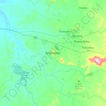
Name: Botshabelo topographic map, elevation, terrain.
Average elevation: 4,770 ft
Minimum elevation: 4,337 ft
Maximum elevation: 6,965 ft
Other topographic maps
Click on a map to view its topography, its elevation and its terrain.
Klein-Modder
South Africa > Free State > Mangaung Metropolitan Municipality > Botshabelo
Average elevation: 4,567 ft
Mangaung Ward 26
South Africa > Free State > Mangaung Metropolitan Municipality
Average elevation: 4,390 ft
Rustfontein Dam
South Africa > Free State > Mangaung Metropolitan Municipality
Average elevation: 4,511 ft
Mangaung Ward 12
South Africa > Free State > Mangaung Metropolitan Municipality > Bloemfontein
Average elevation: 4,587 ft
Bloemspruit
South Africa > Free State > Mangaung Metropolitan Municipality > Bloemfontein
Average elevation: 4,514 ft
Wag-n'-Bietjie Park
South Africa > Free State > Mangaung Metropolitan Municipality > Bloemfontein
Average elevation: 4,629 ft