
Loughborough topographic map
Interactive map
Click on the map to display elevation.
About this map
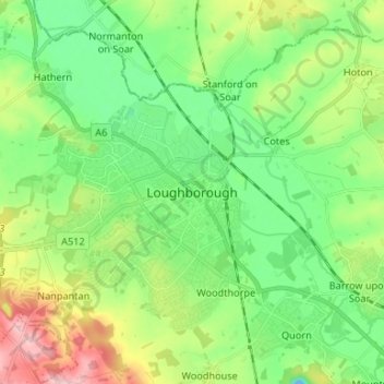
Name: Loughborough topographic map, elevation, terrain.
Average elevation: 200 ft
Minimum elevation: -33 ft
Maximum elevation: 617 ft
Other topographic maps
Click on a map to view its topography, its elevation and its terrain.
Shepshed
United Kingdom > England > Leicestershire > Charnwood
Shepshed, Charnwood, Leicestershire, England, United Kingdom
Average elevation: 364 ft
Sileby
United Kingdom > England > Leicestershire > Charnwood
Sileby, Charnwood, Leicestershire, England, United Kingdom
Average elevation: 226 ft