
Santa Marta topographic map
Interactive map
Click on the map to display elevation.
About this map
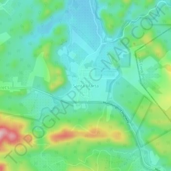
Name: Santa Marta topographic map, elevation, terrain.
Location: Santa Marta, Cayo, Belize (17.07202 -88.63190 17.11202 -88.59190)
Average elevation: 449 ft
Minimum elevation: 217 ft
Maximum elevation: 1,066 ft
Belize has a tropical climate with pronounced wet and dry seasons, although there are significant variations in weather patterns by region. Temperatures vary according to elevation, proximity to the coast, and the moderating effects of the northeast trade winds off the Caribbean. Average temperatures in the coastal regions range from 24 °C (75.2 °F) in January to 27 °C (80.6 °F) in July. Temperatures are slightly higher inland, except for the southern highland plateaus, such as the Mountain Pine Ridge, where it is noticeably cooler year round. Overall, the seasons are marked more by differences in humidity and rainfall than in temperature.