
Hoher Tenn topographic map
Interactive map
Click on the map to display elevation.
About this map
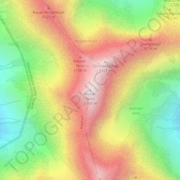
Name: Hoher Tenn topographic map, elevation, terrain.
Location: Hoher Tenn, Kaprun, Zell am See, Salzburg, 5710, Österreich (47.17996 12.75868 47.18006 12.75878)
Average elevation: 8,907 ft
Minimum elevation: 6,860 ft
Maximum elevation: 10,945 ft
Other topographic maps
Click on a map to view its topography, its elevation and its terrain.
Großes Wiesbachhorn
Österreich > Salzburg > Kaprun
Großes Wiesbachhorn, Kaprun, Zell am See, Salzburg, 5710, Österreich
Average elevation: 9,449 ft