
Castillo de Loarre topographic map
Interactive map
Click on the map to display elevation.
About this map
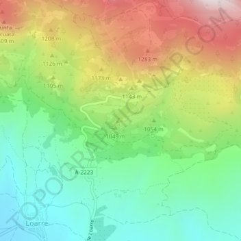
Name: Castillo de Loarre topographic map, elevation, terrain.
Average elevation: 3,369 ft
Minimum elevation: 2,431 ft
Maximum elevation: 4,813 ft
Other topographic maps
Click on a map to view its topography, its elevation and its terrain.
Linás de Marcuello
España > Aragón > Hoya de Huesca > Loarre
Linás de Marcuello, Sarsamarcuello, Loarre, Hoya de Huesca, Huesca, Aragón, 22800, España
Average elevation: 2,556 ft