
Vale de Santarém topographic map
Interactive map
Click on the map to display elevation.
About this map
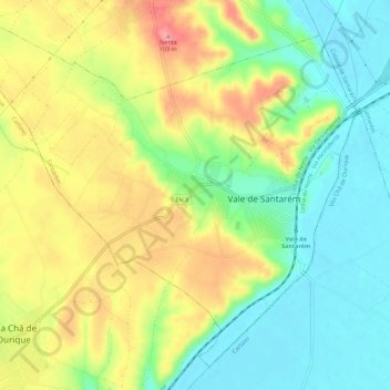
Name: Vale de Santarém topographic map, elevation, terrain.
Location: Vale de Santarém, Santarém, 2005-039, Portugal (39.17314 -8.77174 39.21175 -8.71518)
Average elevation: 115 ft
Minimum elevation: 3 ft
Maximum elevation: 338 ft
Other topographic maps
Click on a map to view its topography, its elevation and its terrain.
Póvoa da Isenta
Portugal > Santarém > Santarém
Póvoa da Isenta, Santarém, Portugal
Average elevation: 161 ft
Arneiro das Milhariças
Portugal > Santarém > Santarém
Arneiro das Milhariças, Santarém, Portugal
Average elevation: 325 ft
Casével e Vaqueiros
Portugal > Santarém > Santarém
Casével e Vaqueiros, Santarém, Portugal
Average elevation: 217 ft
Póvoa de Santarém
Portugal > Santarém > Santarém
Póvoa de Santarém, Santarém, 2000, Portugal
Average elevation: 200 ft
Amiais de Baixo
Portugal > Santarém > Santarém
Amiais de Baixo, Santarém, 2835-333, Portugal
Average elevation: 433 ft