
Maghnia topographic map
Interactive map
Click on the map to display elevation.
About this map
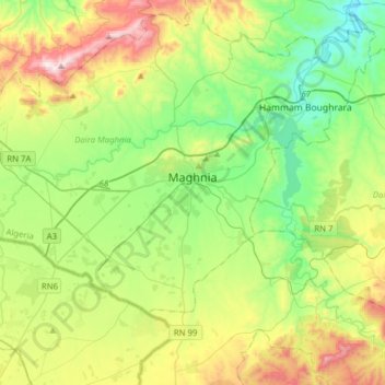
Name: Maghnia topographic map, elevation, terrain.
Location: Maghnia, Daïra Maghnia, Tlemcen, 13300, Algérie (34.75638 -1.97452 34.91693 -1.66292)
Average elevation: 1,535 ft
Minimum elevation: 653 ft
Maximum elevation: 3,317 ft
Other topographic maps
Click on a map to view its topography, its elevation and its terrain.
Sidi El Machehour
Algérie > Tlemcen > Daïra Maghnia > Hammam Boughrara
Sidi El Machehour, Hammam Boughrara, Daïra Maghnia, Tlemcen, Algérie
Average elevation: 1,322 ft