
Make a donation
Gear up for your next adventure:
As an Amazon Associate, this site earns from qualifying purchases at no extra cost to you.
São Sebastião topographic map
Click on the map to display elevation.
Make a donation
Gear up for your next adventure:
As an Amazon Associate, this site earns from qualifying purchases at no extra cost to you.
About this map
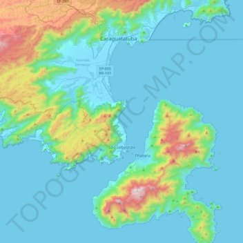
Name: São Sebastião topographic map, elevation, terrain.
Average elevation: 663 ft
Minimum elevation: -13 ft
Maximum elevation: 4,357 ft
Make a donation
Gear up for your next adventure:
As an Amazon Associate, this site earns from qualifying purchases at no extra cost to you.
Other topographic maps
Click on a map to view its topography, its elevation and its terrain.
Praça Doutor Emíilio Ribas
Brazil > São Paulo > Região Metropolitana do Vale do Paraíba e Litoral Norte > Pindamonhangaba
Average elevation: 1,814 ft
Serra da Mantiqueira
Brazil > São Paulo > Região Metropolitana do Vale do Paraíba e Litoral Norte > Queluz
The Serra da Mantiqueira is a part of the Atlantic Forest ecosystem. Despite the clearing of the land for livestock raising, the difficult access to many areas has made possible for sanctuaries of well-preserved forest to still exist, with trees such as the jacarandá, Spanish cedar, canjerana, guatambu, ipê,…
Average elevation: 7,451 ft