Geolocate

Sukkur topographic map

Click on the map to display elevation.

About this map

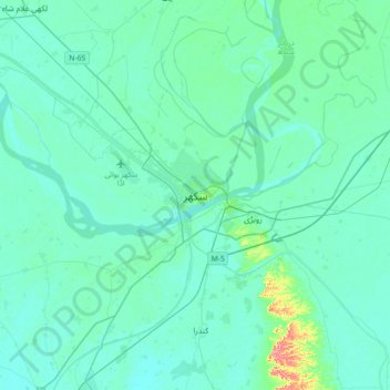
Name: Sukkur topographic map, elevation, terrain.

Location: Sukkur, Sukkur City Taluka, Sukkur District, Sukkur Division, 65200, Pakistan (27.53619 68.69888 27.85619 69.01888)

Average elevation: 207 ft

Minimum elevation: 174 ft

Maximum elevation: 453 ft

Other topographic maps

Click on a map to view its topography, its elevation and its terrain.

Indus

Pakistan > Sukkur District

In the uppermost, highest part of the Indus River basin there are relatively few genera and species: Diptychus, Ptychobarbus, Schizopyge, Schizopygopsis and Schizothorax snowtrout, Triplophysa loaches, and the catfish Glyptosternon reticulatum. Going downstream these are soon joined by the golden mahseer Tor…

Average elevation: 197 ft

New Sukkur Taluka

Pakistan > Sukkur District

Average elevation: 203 ft

Gear up for your next adventure:

📶Satellite Messenger - Communication device off‑grid
🧯Emergency Survival Kit - All‑in‑one survival essentials for the backcountry
💧Water Purification System - Clean water on the trail with reliable purifiers
🌐World Map Poster - Decorative world maps with topographic info
🔊Portable Camp Speaker - Music and alerts at camp

As an Amazon Associate, this site earns from qualifying purchases at no extra cost to you.