
Ouenza topographic map
Interactive map
Click on the map to display elevation.
About this map
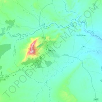
Name: Ouenza topographic map, elevation, terrain.
Location: Ouenza, daïra Ouenza, Tébessa, 12003, Algérie (35.88168 8.05137 36.00378 8.29082)
Average elevation: 1,814 ft
Minimum elevation: 1,430 ft
Maximum elevation: 4,009 ft
Other topographic maps
Click on a map to view its topography, its elevation and its terrain.
El Meridj
Algérie > Tébessa > daïra Ouenza
El Meridj, daïra Ouenza, Tébessa, Algérie
Average elevation: 2,008 ft