
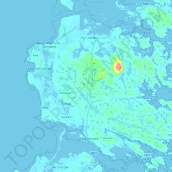
Àird topographic map
Interactive map
Click on the map to display elevation.
About this map
Name: Àird topographic map, elevation, terrain.
Location: Àird, Western Isles, Scotland, United Kingdom, Benbecula (57.39877 -7.41201 57.49401 -7.19778)
Average elevation: 16 ft
Minimum elevation: -13 ft
Maximum elevation: 397 ft
There is a dense cluster of lochs across almost the entire island, and almost all of the island is below 20 metres (70 feet) in elevation.
Other topographic maps
Click on a map to view its topography, its elevation and its terrain.
Tigharry
United Kingdom > Scotland > Western Isles
Tigharry, Western Isles, Scotland, HS6 5DE, United Kingdom
Average elevation: 36 ft
Reef
United Kingdom > Scotland > Western Isles
Reef, Western Isles, Scotland, HS2 9HU, United Kingdom
Average elevation: 59 ft
Scarista
United Kingdom > Scotland > Western Isles
Scarista, Western Isles, Scotland, HS3 3HX, United Kingdom
Average elevation: 197 ft
Vatersay
United Kingdom > Scotland > Western Isles > Vatersay
Vatersay, Western Isles, Scotland, United Kingdom
Average elevation: 62 ft
Tong
United Kingdom > Scotland > Western Isles
Tong, Western Isles, Scotland, HS2 0HJ, United Kingdom
Average elevation: 49 ft
Tarbert
United Kingdom > Scotland > Western Isles
Tarbert, Western Isles, Scotland, HS3 3DB, United Kingdom
Average elevation: 285 ft
St Kilda
United Kingdom > Scotland > Western Isles
St Kilda, Western Isles, Scotland, United Kingdom
Average elevation: 36 ft