
Plech topographic map
Interactive map
Click on the map to display elevation.
About this map
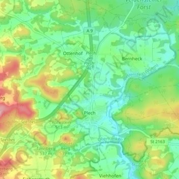
Name: Plech topographic map, elevation, terrain.
Average elevation: 1,558 ft
Minimum elevation: 1,398 ft
Maximum elevation: 1,860 ft
Other topographic maps
Click on a map to view its topography, its elevation and its terrain.
Fichtelberg
Germany > Bavaria > Landkreis Bayreuth
Fichtelberg, Landkreis Bayreuth, Bavaria, 95686, Germany
Average elevation: 2,287 ft
Gottelhof
Germany > Bavaria > Landkreis Bayreuth > Hollfeld
Gottelhof, Hollfeld, Hollfeld (VGem), Landkreis Bayreuth, Bavaria, 95515, Germany
Average elevation: 1,335 ft
Röhrig
Germany > Bavaria > Landkreis Bayreuth > Bindlacher Berg
Röhrig, Bindlacher Berg, Bindlach, Landkreis Bayreuth, Bavaria, 95463, Germany
Average elevation: 1,345 ft
Gefrees
Germany > Bavaria > Landkreis Bayreuth
Gefrees, Landkreis Bayreuth, Bavaria, 95482, Germany
Average elevation: 1,919 ft