
Alcochete topographic map
Interactive map
Click on the map to display elevation.
About this map
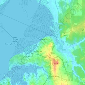
Name: Alcochete topographic map, elevation, terrain.
Location: Alcochete, Setúbal, Portugal (38.67137 -9.03106 38.82614 -8.81030)
Average elevation: 30 ft
Minimum elevation: -10 ft
Maximum elevation: 217 ft
Other topographic maps
Click on a map to view its topography, its elevation and its terrain.
Cercal do Alentejo
Cercal do Alentejo, Cercal, Santiago do Cacém, Setúbal, 7555-254, Portugal
Average elevation: 545 ft
Fonte da Telha
Portugal > Setúbal > Costa da Caparica
Fonte da Telha, Costa da Caparica, Almada, Setúbal, 2825-486, Portugal
Average elevation: 112 ft
Praia do Sargaço
Praia do Sargaço, Castelo, Sesimbra, Setúbal, Portugal
Average elevation: 102 ft
São Francisco da Serra
Portugal > Setúbal > São Francisco da Serra
São Francisco da Serra, Santiago do Cacém, Setúbal, Portugal
Average elevation: 623 ft